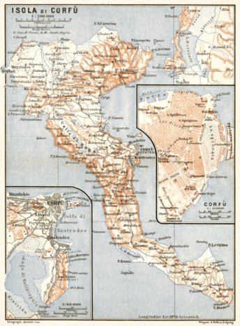
Corfu Isle map, 1912. With town plan of Corfu (Kerkyra)
$1.99 USD
Historical map of the Isle of Corfu Isle and town of Corfu (Kerkyra) from 1912, with location in Greece, produced by Wagner & Debes, at the scale of 1:300,000. The map contains inset(s) drawn to scale(s) of 1:15,000, 1:60,000. This digitally re-mastered image is a part of the Discus Media 190...
Geographic area:
Category:
Historical
Size:
4.32MB
Publication:
1912
Language:
French
Map bounds
Check nearby mapsWhat you get with Avenza Maps

Reliable mapping tools
Record GPS tracks, add placemarks, add photos, measure distances, and much more.

Locate yourself with GPS
Avenza Maps offline GPS app on your mobile device can locate you on any map, without WiFi or network connectivity.

The best maps by the best publishers
Download professionally curated digital maps on the Avenza Map Store from the best-renowned publishers.