1
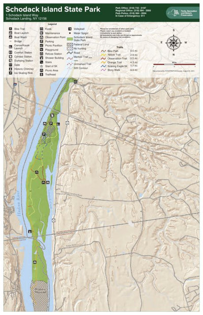
Schodack Island State Park Trail Map
- Cycling
- Hiking
Free
Schodack Island State Park sits off the eastern shore of the Hudson River just south of Albany. Approximately seven miles of Hudson River and Schodack Creek shoreline bound the 1,052-acre site. The park has been designated a State Estuary, and a portion of the park shelters a Bird Conservation Ar...
Geographic area:
Category:
Parks & Forests
Size:
8.7MB
Publication:
April 2014
Language:
English
Map bounds
Check nearby maps Customer Reviews
5.0 Based on 1 Reviews
Write a Review Ask a Question - Reviews
- Questions
Filter Reviews:
C
07/23/2021
Customer
High Falls, New York, United States
Good state campground deserves a good map
Perfect map for exploring a state park with bird sanctuary, bike trail, hiking trails, kayaking, docks, and well cared for campsites.
What you get with Avenza Maps

Reliable mapping tools
Record GPS tracks, add placemarks, add photos, measure distances, and much more.

Locate yourself with GPS
Avenza Maps offline GPS app on your mobile device can locate you on any map, without WiFi or network connectivity.

The best maps by the best publishers
Download professionally curated digital maps on the Avenza Map Store from the best-renowned publishers.