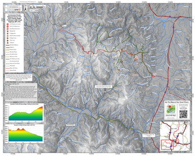
Butte CDT Rocky Ridge Trailhead to MT Hwy 274 (Map 4 of 4)
- Hiking
Free
Continental Divide Trail through the Butte Ranger District on the Beaverhead National Forest. Map begins at Rocky Ridge Trailhead (accessed from I-15 Exit 111) and continuing to the MT Hwy 274 (Mill Creek Highway).
Geographic area:
Category:
Parks & Forests
Size:
27.88MB
Publication:
May 2014
Language:
English
Map bounds
Check nearby mapsWhat you get with Avenza Maps

Reliable mapping tools
Record GPS tracks, add placemarks, add photos, measure distances, and much more.

Locate yourself with GPS
Avenza Maps offline GPS app on your mobile device can locate you on any map, without WiFi or network connectivity.

The best maps by the best publishers
Download professionally curated digital maps on the Avenza Map Store from the best-renowned publishers.